
.jpeg)
.png)
Farmers with an eye toward the approaching harvest will appreciate the fall forecast.
The autumn season is forecast to be on the relatively warmer side and leaning toward drier than normal conditions, according to the Climate Prediction Center’s outlook for September, October and November released Thursday, Aug. 21. Those conditions are conducive to a smooth harvest as crops dry down.

A rainbow arcs over a field of alfalfa in Colfax County, Neb. in June. Summer rains help drought conditions improve. A warm and possibly drier fall is predicted, which would be welcome for harvest season.
Precipitation chances in parts of the Central Plains are more favorable than in others, notably a wetter eastern Nebraska and Kansas versus the western sides of both states.
The summer has been hot and very humid in most areas east of the Rockies. This was due to an almost continuous connection to the Gulf of Mexico earlier in the summer. After decent rains, there’s been plenty of evapotranspiration, the term for when moisture transfers from land to air as crops and other vegetation grows rapidly.
In some areas, such as eastern South Dakota, it’s especially wet, causing standing water and minor flooding along the James River.
“Crop-wise, the USDA is calling for record corn this year across the corn belt. Conditions have been very good for corn, and the corn prices show it,” said Doug Kluck, regional climate service director, retired from the National Oceanic and Atmospheric Administration (NOAA).
A pleasant break from the heat and dry weather in late August was expected to bring in unusually cooler temperatures in the north central U.S. and a forecast for very heavy rains across Colorado, New Mexico and the southern plains. This moisture is likely due to tropical moisture from the south colliding with a cold front, Kluck said.
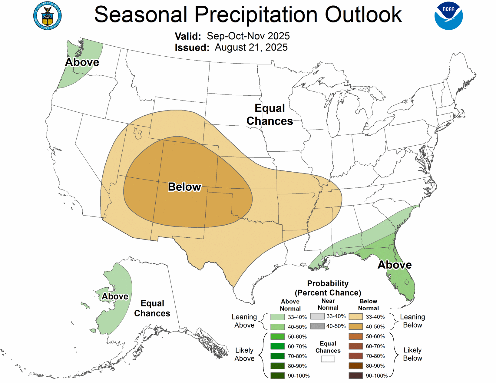
Fall precipitation chances in parts of the Central Plains are more favorable than in others, notably a wetter eastern Nebraska and Kansas versus the western sides of both states.
Longer term, weather begins to take on a more La Niña-esque pattern for early fall.
“Warm conditions are likely to prevail especially in September, but especially into October and November across the U.S. Precipitation probabilities take a slight leaning toward dry especially during September and mainly for the High Plains and Rockies; overall leaning dry,” Kluck observed.
This is likely to be a weak and potentially short La Niña.
“What that may mean for our winter is always hard to say,” he said. “Generally colder wetter north-northwestern U.S. and warmer drier southern U.S., but as we all know that does not always happen.”
Nebraska-Kansas outlook
The Climate Prediction Center’s (CPC) three-month autumn outlook favors mild temperatures, but the precipitation outlook doesn’t necessarily favor wet or dry at this time for Nebraska and Kansas.
“Technically, the CPC has issued a La Niña watch, which often spells a warmer and drier autumn, but there is only a 50-50 chance of La Niña,” said Michael L. Moritz, Warning Coordination Meteorologist with the National Weather Service in Hastings, Nebraska.
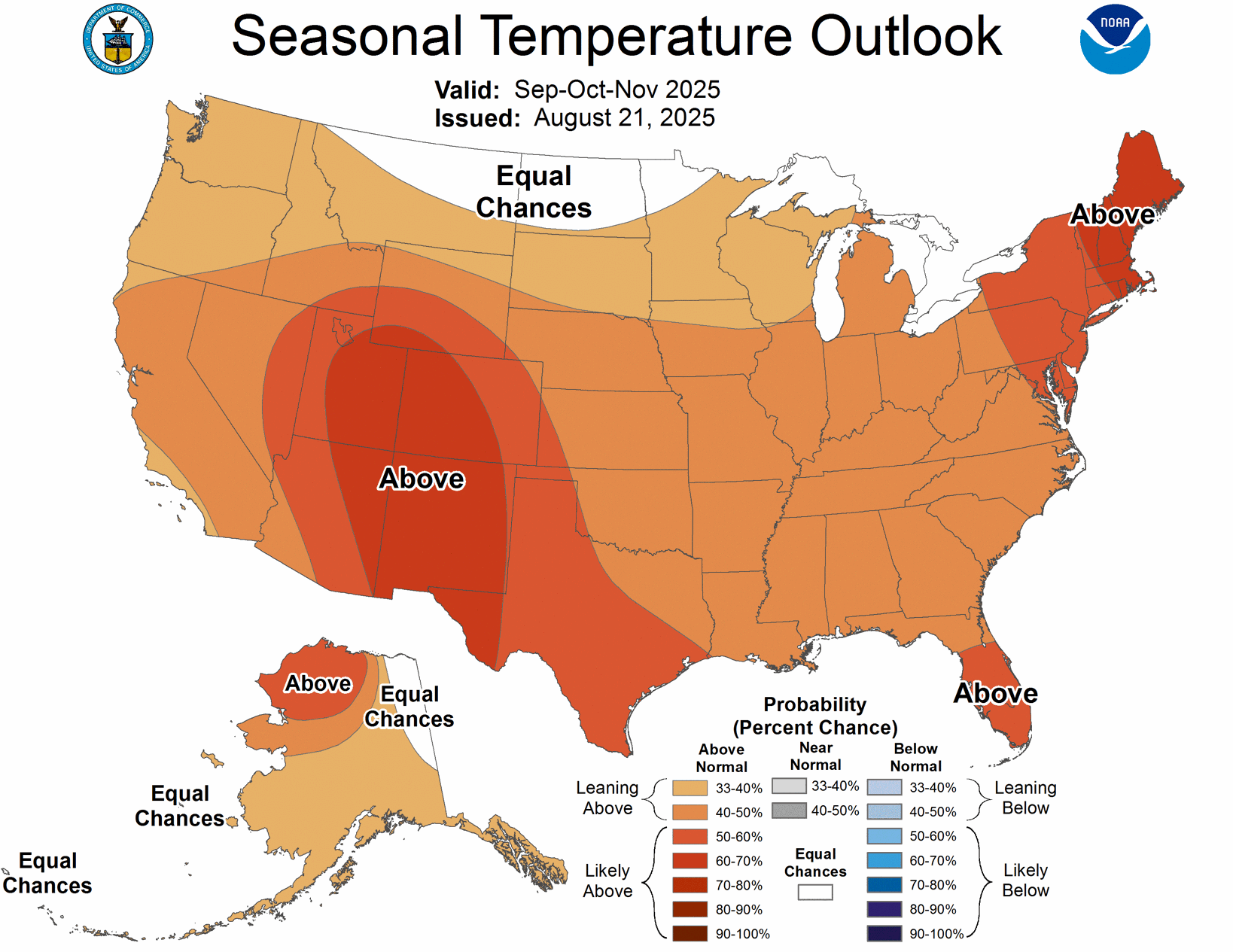
Warm conditions are likely to prevail September and into October and November across the U.S.
That means impacts of La Niña will likely be muted. Nebraska and Kansas have an increased likelihood of above-normal temperatures, but probabilities favor warmer conditions than average for the fall months, he said.
For precipitation, the outlook suggests an equal chance of having either above-normal, near-normal, or below-normal precipitation across most of Nebraska and Kansas. This indicates a higher degree of uncertainty regarding rainfall amounts, with no strong signal for either wetter or drier than average conditions. Portions of western Kansas may lean slightly towards below-normal precipitation, but this signal is not widespread across the two states.
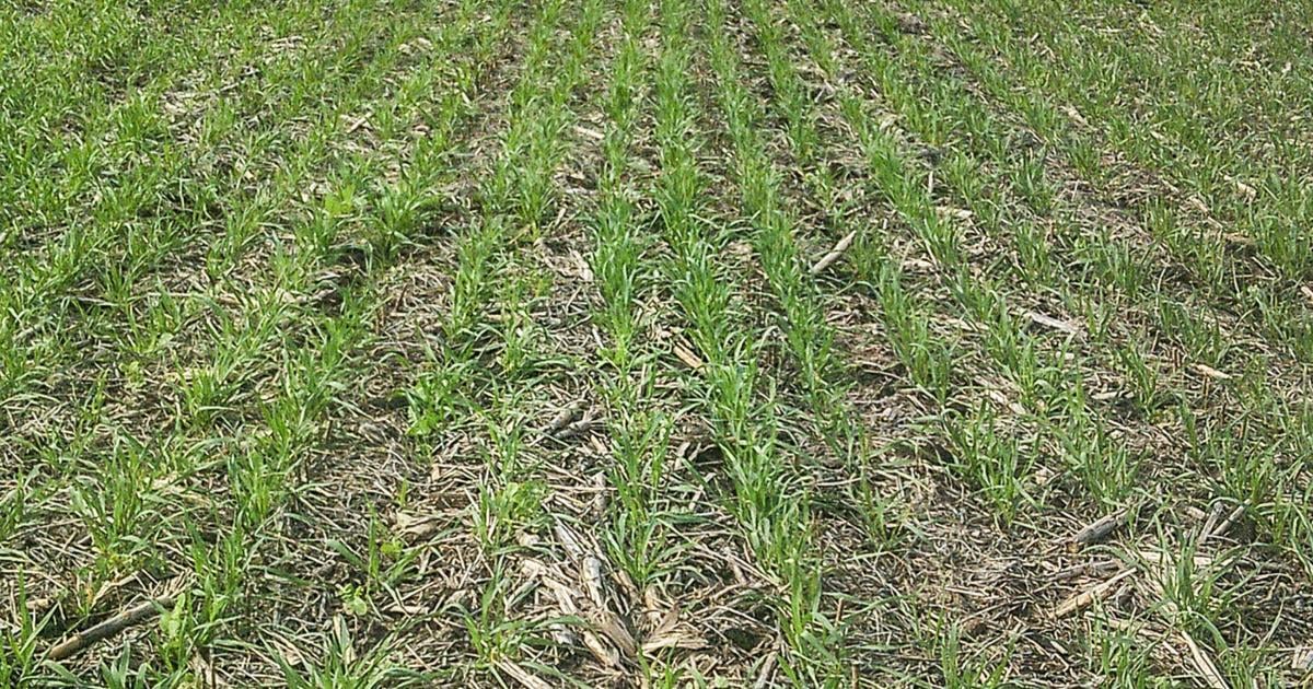
Over the past few years, the region has experienced warm autumn temperatures, a trend likely to continue this season.
“Such warmth can accelerate crop maturation, affecting harvest schedules. Despite this, given the uncertain precipitation trends, producers should anticipate normal rainfall variability and adjust their end-of-season crop and field preparation accordingly,” Moritz said.
While drought conditions have improved across much of Nebraska and Kansas, the anticipated drier trend to the west this fall may gradually expand eastward into western Nebraska and Kansas.
The fall also marks the beginning of a second wildfire season in the region, particularly after the first freeze.

Drought conditions have improved across much of Nebraska and Kansas as of Aug. 19.
“Although beneficial for most producers, the wetter-than-normal summer led to significant growth of grasses, which serve as fine fuels for wildfires,” Moritz said. “Therefore, warm and dry conditions could lead to an active fall wildfire season in certain parts of Nebraska and Kansas.”
Southwest Iowa outlook
Initial September climatological outlooks from the Climate Prediction Center show a signal for warmer temperatures across southwestern Iowa, but no clear guidance on rainfall.
“Climate modeling is suggesting a brief transition to La Niña through fall, with a return to neutral conditions into the winter months,” said Justin Glisan, Ph.D., state climatologist of Iowa.
While the correlation between La Niña and fall weather behavior is not as robust as in winter, Glisan notes some past years with similar weather patterns suggest increased potential for warmer and drier conditions for southwest Iowa.
Freelance writer Amy Hadachek is a two-time Emmy Award winning meteorologist and a storm chaser who earned her NWA and AMS Broadcast Meteorology Seals of Approval. She and her husband live on a diversified farm in Kansas. Reach her at editorial@midwestmessenger.com.
Be the first to know
Get local news delivered to your inbox!


.png)
